| Title: | Trappers Butte |
| Area: | Willamette National Forest |
| Elevation: | 4960 Feet |
| Elevation_Gain: | 1400 |
| Trail: | Scar Mountain |
| Misc: | This trail to Trappers Butte is part of the 27 mile loop system called the Old Cascades Crest Trail, which links together other well known sites as the Three Pyramids and Crescent Mountain. |
| Links: | Old Cascades Crest Trail Area, |
| Notes: | The area between Trappers Butte and Fisher Point is drained to the west by Lynx Creek. Names like these certainly hint to the trapping heritage of this area. Trappers Butte itself is mainly overshadowed by the more dramatic Scar Mountain to the NW, and in fact the trail across both these peaks of the Old Cascades bear the Scar Mountain name. The east end of this trail, which is the closest route to the top of Trappers Butte, is a modern recreation trail with a gentle grade and wide surface. It's four miles from the North Pyramid Trailhead parking lot, my suggested starting point, to the top of Trappers Butte. If you want more of a hike it's another two miles to the top of Scar Mountain. |
| Trail_Number: | 3802 |
| Route: | From Detroit, continue on Highway 22 to Parrish Lake Road. Take Parrish Lake Road for 4.5 miles to the North Pyramid Trailhead parking on the left side. The Scar Mt Trail begins on the right hand side of the road. |
| TH_elevation: | 3560 |
| Distance: | 4.0 |
| USGS_15: | Detroit |
| USGS_75: | Coffin Mountain |
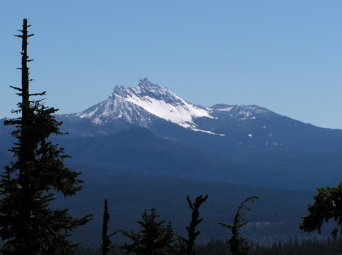
Three Fingered Jack from the summit of Trappers Butte - - - 9/21/04 |
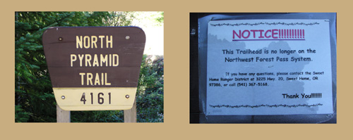
Park at the North Pyramid Trailhead - - - Northwest Forest Pass no longer required |
| Type: | Peak |
| Day_Hike: | yes |
| Mountain_Biking: | yes |
| Scenic: | yes |
| Solitude: | yes |