| Date: April 25, 2002 | | Location Memaloose Hills | | Where: Columbia Gorge National Scenic Area | Memaloose State Park, located in the Columbia River Gorge, is cut right into by Interstate 84. MAP Those traveling west have the convenience of a Rest Stop as well as access to a lovely campground for overnight camping. East bound travelers also have a Rest Stop, and here is a secret, -----access to a wonderful hiking area. To hike here wander up the cement walk to behind the older, or western restrooms. You will find a path that leads west to an abandoned road, the Chatfield Wagon Road, named after Roy Chatfield, an early fruit grower in the area and donor of Memaloose Park. Pass through the gate and hike up this road past a water tower. This is on state property so do not feel that you are trespassing. This is an interesting road, carved out of the rock bluff, and soon you will be seeing Larkspur, Oregon Grape, various Parsleys, Paintbrushes, and big showy Balsamroot. Look out for poison oak, but don't overlook the Chocolate Lilys in their midst.
| 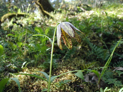 | | Chocolate Lily You can easily be distracted here and wander left or right looking at flowers, but if you stay on the road it will intersect with the Historic Columbia River Highway. Hiking east along the edge of the road will take to the Memaloose Overlook. If, however you want to explore the several hills in the area walk west a short distance to a lightly trod path up around private property. Only attempt this if you enjoy exploring or with someone you has hiked this route before. The route is marked with blue tape at intervals. The first hill you climb is Hudson Hill, so named because a "Hudson" lamp was used for early river navigation. The summit gives you great views off to the southwest of Mt Hood.
| 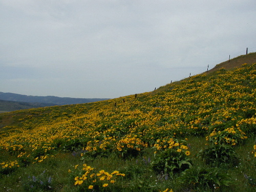 | | Castilleja Hill The second hill is known as Castilleja Hill, and its south-facing slope is literally covered with huge flowering Balsamroot. Here on the east half of the hill you are on Mt Hood National Forest property, so please respect the private property on the west side of the fence. It is however an opportunity for a very graphic reminder of the difference for Balsamroot in gazed and non-grazed land. The route continues east out across a large field and across a paved road. Cross a couple of fences and continue east to two rounded hills. From these hills you can easily spot Rowena Crest and Tom McCall Point to the east. Descend down and north, crossing the highway. Follow the blue ribbons and the trail winds its way through the oaks back to the rest area.
|  | | Balsamroot flower up close |
|
|