| Title: | Moon Falls Trail |
| Area: | Umpqua National Forest |
| Elevation: | 2900 - 3000 Feet |
| Elevation_Gain: | -100 |
| Trail: | Moon Falls |
| Misc: | A good map for this area is the Umpqua National Forest - Cottage Grove Ranger District Map. |
| Links: |
Moon Falls Trail
Thundering Waters
Trip Journals - 7/13/09, 4/23/10 |
| Notes: | This trail in the Cottage Grove District of the Umpqua National Forest requires a little extra driving to get to, but it can be combined with the Spirit Falls Trail and the Pinard Falls Trail for more hiking. |
| Trail_Number: | 1423 |
| Route: | From Cottage Grove, take Row River Road, #2400 east 19 miles to Road #17. Turn left (northeast) on Layng Creek Road, #17, and continue for 8.8 miles to Road #1790 and travel for 0.25 miles to Road #1702. Turn left on #1702 and travel for 2.8 miles to Road #1702-728. Turn right on Road #1702-728 and continue for 0.3 miles, turning left on spur Road #1702-203 and continue to the trailhead at the roads end. |
| TH_elevation: | 2950 |
| Distance: | 0.5 |
| USGS_75: | Holland Point |
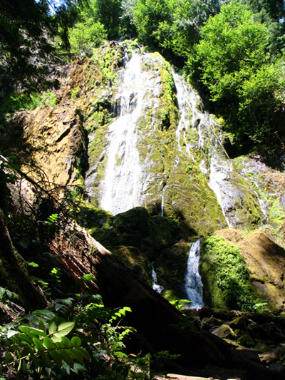
Moon Falls - July 9, 2009 - - - photo by Stephanie Schnabel |
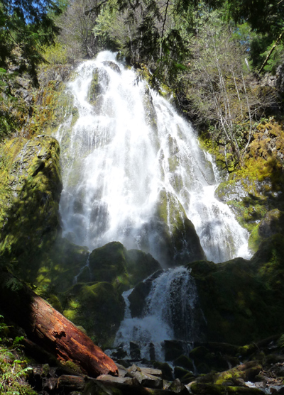
Moon Falls - April 23, 2010 |
| Type: | Trail |
| Family_Outing: | yes |
| Day_Hike: | yes |
| Scenic: | yes |