| Title: | Diamond Lake |
| Area: | Eagle Cap Wilderness |
| Size: | 11 Acres |
| Depth: | 24 Feet |
| Elevation: | 7041 Feet |
| Elevation_Gain: | 1611 |
| Camp_Sites: | 1 |
| Trail: | West Eagle & Tombstone Lake |
| Misc: | Note: There is no limit on the size and number of brook trout taken from these lakes |
| Links: | Eagle Cap Wilderness, Trip Journal - 8/25/03 |
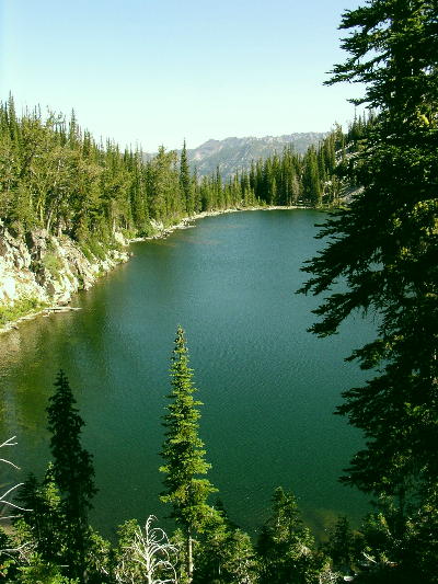
| Notes: | Diamond Lake is located off of the Tombstone Trail about 1/2 mile north of Tombstone Lake. Its fairly easy to find as a well used path descends to its rocky shoreline. Steep rocky walls surrond the late on three sides. Campsites are very minimal. I would recommend camping at Tombstone Lake area. Interesting enough, Diamond Lake is not named for its shape, but because a sheep herder named Diamond agreed to stock the lake with fish. |
| Trail_Number: | 1934 & 1943 |
| Route: | From La Grande, take I-84 south to exit 265 and travel east on Highway 203 14 miles to Union. In the center of town, turn left of Beakman Street and continue past Catherine Creek State Park to the summit, turning on Road 77 to West Eagle Meadows. The last 5 miles are rough and rocky. A Northwest Forest Pass is required to park here. |
| TH_elevation: | 5430 |
| Distance: | 7.0 |
| USGS_75: | Steamboat Lake |
| Reference: | Backpacking Oregon by Lorain / Hiking Oregon's Eagle Cap Wilderness / Oregon Geographic Names by McArthur |
Diamond Lake - - - - - August 25, 2003 |
| Backpack: | yes |
| Fishing: | yes |
| Scenic: | yes |
| Solitude: | yes |