| Date: October 14, 1999 | | Location Canada to Mexico - #26 - Laytonville to Ukiah | | Where: Super 8 Motel, Ukiah | Thursday - Jeanette writes
Adventure in "Paradise"
"If Jim were to describe today's adventure you might think that he was fabricating or perhaps mean spirited... he isn't. In fact right in the middle of today's adventure - when he might have said, "I told you so..." he didn't.
It all started rather innocently in Garberville on Tuesday. I was quizzing a waitress about motel possibilities for Wednesday. She gave good information then volunteered to tell me about a risky section of highway 101 that we would encounter on Thursday.
We asked several people for input. Herb Colt, who lives nearby in Clear
Lake reassured us. Our friends Lon & Nina Carlson who send us daily weather reports and encouragement also reassured us but checked a computer map program for alternate route at our request. We felt that the "risk" may have been overstated by someone who doesn't cycle. So 101 was our decision.
This morning I had a scary moment with a narrow bike lane and a passing truck. Suddenly I was back at square one with the waitress' warning. Just to be sure, we stopped at the bicycle store in Willits. The young man there told us that, in fact, we had already ridden the risky section. BUT he didn't stop there - he pulled out a map and pointed out the alternate route that we had decided not to take. Then he recommended it as much better, safer and easier than 101. He did say that there was "some gravel, but no worse than his parking lot."
We took the detour.
First we climbed up 3.5 miles of beautiful, narrow canyon with light traffic except for an occasional belly-dump gravel truck climbing the hill to the landfill. Near the 2,000' summit an approaching log truck stopped near me and the driver rolled down his window. He wanted to warn us that just around the next corner was a very large black bear right in the middle of the road. We continued carefully, postponed our picnic lunch, and never saw the bear.
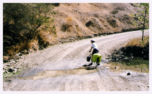
Next we got a refreshing cool shaded coast down 3.5 miles to the bottom of the hill and turned on to the gravel.
(Now it begins to get ugly.)
The gravel WASN'T just like the parking lot after all. It was four miles of terrible washboard that climbed and dropped repeatedly. Many times it was too steep to peddle so we would have to get off and walk. Many times the road disappeared as it crossed a stream and had been washed away. It was hot and dusty. We were surrounded by dry brown grassy hills, oaks and lots of poison oak. It took us one hour to go 3 miles. Just when I thought it might not end, we reached pavement again. The riding improved, but the wilderness changed into what we later learned is a part of the "Emerald
Triangle" - an area that feels dangerous with barking watchdogs and high chain link fences to protect valuable marijuana crops.
It was a relief when we got close to town and into another valuable California crop - grapes.
Our adventure added 7 miles and two hours to today's route and some memories that we'll surely laugh about soon.
Tonight we are safely in our motel in Ukiah. Tomorrow we meet Bunni at
Santa Rosa!"
|  | Days Distance: 53.3 miles
Days Climb: 2120 feet
Days Average Speed: 10.1 mph
Days Max Speed: 34.0 mph
Total Distance: 1243.4 miles |
|
|